Introduction
This study examines the characteristics, use and effects of the Grad multi barrel rocket launcher. It is part of a series of technical studies on explosive weapons undertaken by the GICHD, providing evidence and contributing to the analysis. A version of this study can be found in the final report on Characterisation of Explosive Weapons (GICHD, 2017) as Annex B.
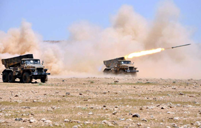
Photo 1. Syrian Arab Army BM-21 MBRLs during a training exercice in 2012 (photo credit: Reuters).
Since its introduction in the early 1960s, the presence and use of 122 mm BM-21 Grad (Град; ‘Hail’) type multi barrel rocket launchers has become ubiquitous in conflict zones throughout the world. Its simplicity, combined with the ability to deliver massive firepower from a relatively light mobile platform, has led to its rapid, widespread adoption. This weapon system has been widely copied, and now copies, variants, and derivatives can be found in the inventories of over 50 state armed forces, as well as numerous non-state armed groups (Schroeder, 2014; IISS, 2010; ARES, n.d.).
As the BM-21 is a relatively old design, first developed in the late 1950s, some of these variants have resulted in the inclusion of more modern weapon characteristics, such as advanced fire-control systems and more advanced aerodynamic properties for the rockets themselves. This report limits itself to the study of the original BM-21 (the 9K51 in Soviet service) and those copies and variants which closely approximate the characteristics of the BM-21. 122 mm variants of the BM-21 that are significantly more modern than the original design have not been widely employed in conflict zones, and are not addressed in this report.
The Russian nickname ‘Hail’ is an appropriate moniker for a weapon system that can launch up to forty 122 mm rockets in some 20 seconds, at ranges of up to 20 km. Designed to deliver its munitions over an area rather than a point target, the Grad is not a precision weapon; at a range of 20 km, when a full salvo of 40 rockets is fired, the lethal area extends up to 600 m x 600 m (Jelic et al., 2013). When the rockets impact, they produce a substantial fragmentation effect. The multiple instances of its use in populated areas across the world have resulted in significant numbers of civilian deaths and injuries. In addition to the human cost of using Grads in populated areas, there has been devastating damage to civilian objects including residential buildings, businesses, and critical infrastructure.
The BM-21 Weapon System
The BM-21 is the successor to the famous Katyusha rocket launchers of World War II, also known as ‘Stalin’s Organs’. Munitions fired by the BM-21 are frequently and incorrectly referred to as ‘Katyusha rockets’. BM-21 stands for Боевая машина-21 (Boyevaya Mashina – 21; ‘Combat Vehicle – 21’). It was first introduced into service in 1963 (Karpenko, 2010). The BM-21 is a multiple barrel rocket launcher (MBRL). The extensive use of BM-21 type systems in populated areas has allowed a large number of case studies to be carried out.
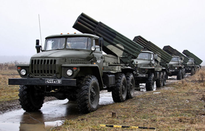
Photo 2. BM-21 Grad on Ural-375D chassis (photo credit: Vitaly V. Kuzmin).
The BM-21 is a vehicle-mounted, multiple barrel rocket launcher. The BM-21 was designed and manufactured at the former Soviet Union State Factory (now NPO Splav) in Tula, Russia. The weapon system has since been widely copied throughout the world. The typical barrel configuration consists of four rows of ten tubes, meaning that each BM-21 can carry and launch up to 40 rockets. When firing its entire complement, a rocket is launched every 0.5 seconds, meaning that it takes a single BM-21 around 20 seconds to launch its full load of rockets (Karpenko, 2010). When the rockets impact the target area, they deliver a blast and fragmentation. After firing, it takes approximately ten minutes to completely reload the BM-21 launch vehicle. The original BM-21 had a maximum range of 20.4 km, but modern versions have seen this range increased to 40 km (Splav, n.d).
The original launch vehicle was a Ural-375D 6×6 truck chassis. In 1976, the Ural-375D launch vehicle was replaced by the newer and more powerful Ural-4320 6×6 truck (Karpenko, 2010). Each BM-21 is supported by a 9T450 re-supply truck with 60 additional rockets. Being mounted on 6×6 trucks gives the BM-21 notable cross-country mobility, which is especially useful after firing, when the launchers must
move quickly to avoid counter-battery fire from enemy artillery (Karpenko, 2010). This ‘shoot and scoot’ behaviour is typical of self-propelled MBRL systems.
Most conventional military forces organise the BM-21 into batteries of four or six systems, so as to ensure that a devastating amount of fire can be brought to bear in a very short period of time. Six launch vehicles can fire 240 rockets in approximately 20 seconds. It is common practice to use several MBRLs to attack the same broad target area.
As BM-21 type systems have been used by many countries and irregular forces, it has been deployed for various purposes and configurations, manifesting in any number of launch vehicles, or even individual launch tubes, used at the same time. For example, Hamas has fired 122 mm rockets, typically individually and with home-made launchers, into Israel from the Gaza Strip. 122 mm rocket motors are also often formed as the basis for improvised rocket-assisted munitions (IRAM) (Jenzen-Jones & Wright, 2016).
The BM-21 was introduced to deliver overwhelming firepower, designed to attack an area rather than a point target. Computer modelling has shown that when fired from 20 km away, a salvo of 40 Grad rockets creates a much larger lethal area of 36 hectares (600 m x 600 m) (Jelic et al., 2013).
TECHNICAL SPECIFICATIONS OF 122 MM ROCKETS FOR THE BM-21
A rocket is a munition that is propelled by a self-contained rocket motor. In its simplest form, a rocket motor consists of a tube in which fuel is burned, with an opening at one end. The escaping gases cause an equal and opposite reaction on the closed end of the tube, propelling the rocket forwards (Ryan, 1982). Thrust is generated by channelling the rapidly expanding gases from the burning rocket fuel through one or more nozzles (venturi). The 122 mm rockets for the BM-21 have seven venturis at the rear of the rocket motor. While rocket motors can contain either liquid or solid fuel, BM-21 systems fire rockets with motors containing only solid rocket fuel. Unlike a missile, an unguided rocket does not adjust its trajectory in flight to precisely strike the target. As such, once the BM-21 has fired an unguided rocket, there is no way to alter its course.
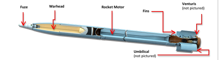
Photo 3. The principal components of a 122 mm rocket for the BM-21 MBRL (photo credit: Federal State Unitary Enterprise (Splav) State Research and Production).
The Fuze
The high explosive fragmentation (HE-FRAG) warheads that are the main focus of this report are usually fitted with MRV series impact fuzes. These are both relatively simple and cheap to manufacture, and they function reliably. An impact fuze will only detonate the warhead when it strikes the target, and is armed in flight, typically some 150-400 m after launch (Tohan, n.d.). Many fuzes in use with 122 mm HE-FRAG rockets will offer three settings: super-quick, short delay, and long delay. The fuze has three primary roles – to ensure safe handling of the rocket during storage, loading, transport, and launch; to only arm itself a safe distance from the launcher when fired; and to ensure the warhead functions at the correct time.
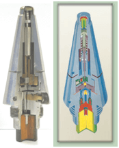
Photo 4. Cutaway photograph and diagram of an MRV-U impact fuze (photo credit: Tohan S.A.; Arcus Co.).
Warheads
The warheads for 122 mm rockets fired by the BM-21 are located towards the front of the munition, behind the fuze, and immediately in front of the rocket motor. The warheads must be robust enough to withstand normal handling stresses, and the forces produced by firing. However, it is important to note that these stresses are much lower than for some other weapon systems, such as artillery guns. For the HE-FRAG rockets that are most commonly fired by the Grad, the steel warhead has an internal matrix of lines scored into it to produce the desired pattern of fragmentation (Razic et al., 2015).
This report concentrates on the high explosive warheads that are used with a variety of 122 mm rockets. The specifications for these rocket types can be found in the section entitled ‘BM-21 High Explosive Rocket Types’. In addition to a variety of high explosive warheads, a wide range of other munition types are also produced for BM-21 type 122 MBRLs, including cargo (cluster), illumination, radio frequency jammer, chemical, and incendiary examples.
The Rocket Motor
The 122 mm rocket motor consists of a body surrounding solid rocket fuel. The rocket motor has a relatively short burn time of approximately three seconds. Despite the short burn time, the Grad produces a lot of visible exhaust, tending to make launch sites readily detectable. In addition to the exhaust, and depending on the location of firing, the launch typically generates a cloud of dust and debris upon launch, increasing the visual signature. It is near-impossible to disguise the launch of 122 mm rockets, so the launch site remains vulnerable to threats such as counter-battery artillery fire. Refer to Photo 5 for an example of the visual signature of a launch.

Photo 5. An example of the visual launch signature from multiple 122mm MBRL firing; in this case, Chinese Type 81 variants (photo credit: Xinhua/Reuters Photo).
122 mm rockets for BM-21 type MBRLs do not have the capability to burn only part of their rocket fuel; therefore the only way to adjust the range of the rockets is by altering the angle of the launcher. A rocket fired at a low angle will generally travel further than a rocket fired at a high angle (see Final Report, section on Accuracy and Precision). The remaining rocket fuel burns, or deflagrates, on impact, which may contribute to human injuries and infrastructure damage. The burning can last tens of seconds, and creates a hot cloud of toxic fumes whilst also being capable of igniting flammable objects in the surrounding area.
Venturi
The primary function of the venturi is to channel and vent the hot propellant gases from the high-pressure combustion chamber of the rocket motor to the open air. This produces thrust, which overcomes the initial inertia, and accelerates the rocket to maximum velocity. Some rockets have a single venturi, and some have multiple. The Grad has seven venturis, all located at the rear of the rocket motor (USSR Ministry of Defence, 1971).
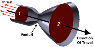
Figure 1. Diagram showing a rocket venturi in action (source: Glenn Research Center, NASA).
The Fins
In order to achieve aerodynamic stability, a rocket uses fins or spins axially (Dullum et al., 2016). The Grad uses a combination of both these methods. The primary method of providing aerodynamic stability is through the use of four wrap-around fins at the rear. When the rocket is launched, it also begins to spin at a relatively slow speed. The spring-loaded fins are wrapped around the rear of the rocket, and held in place by a thin strap, which is burnt through when the rocket launches. As the rear of the rocket leaves the launch tube, the springs push the fins into place, and stabilise the rocket in flight (Dullum et al. 2016).
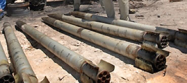
Photo 6. Grad rocket fins in the open position (source: Sean Sutton/MAG).
BM-21 HIGH EXPLOSIVE ROCKET TYPES
This report concentrates on the high explosive (specifically HE-FRAG) warheads fired by BM-21 type systems, of which there are seven different Soviet and Russian types. Of these, five are referred to as being ‘conventional’ designs, produced before 1990. The remaining two are ‘enhanced performance’ designs, emerging in the early 2000s. The seven main HE-FRAG rocket types are introduced below.
9M22 ROCKET
The 9M22 is a fin-stabilised rocket with a steel high explosive fragmentation (HE-FRAG) warhead. The 9N51 warhead contains 6.4 kg of TGAF-5 explosive composition, and generates some 3,920 pre-fragmented fragments. The warhead is manufactured with internal scoring designed to fragment into 1,640 fragments, each weighing 2.4 g. The warhead is double-skinned, with the outer skin only lightly scored, in order to avoid damaging its structural integrity during launch. The outer skin is designed to produce an additional 2,280 fragments, each weighing 2.9 g. The rocket motor contains 20.5 kg of a double-base solid propellant.
| Calibre | 122 mm |
| Weight | 66 kg |
| Warhead weight | 18.4 kg |
| Length | 2870 mm |
| Number of fragments: – pre-fragmented (2.4 g) – partially pre-fragmented (approx. 2.9 g) |
1640 2280 |
| Range of fire | 5 km to 20.4 km |
Source: USSR Ministry of Defence, 1971.
9M22M Rocket
The 9M22M rocket can be fired from both the Grad, and from the single-tube launcher designated the 9P132. It is somewhat shorter than the 9M22 and weighs 46 kg. The warhead has a total weight of 18.4 kg and contains 6.58 kg of TGAF-5. Its maximum range is just under 11 km, but an extended range variant, fitted with an additional rocket motor, known as the 9M22MD was developed to fire out to 15 km.
| Calibre | 122 mm | |
| Weight | 46 kg | |
| Warhead weight | 18.4 kg | |
| Length | 1930 mm | |
| Number of fragments: – pre-fragmented (2.4 g) – partially pre-fragmented (approx. 2.9 g) |
1640 2280 |
|
| Range of fire
|
2 km to 10.8 km
|
|
Source: USSR Ministry of Defence, 1973.
9M22U Rocket
The 9M22U rocket is one of the most commonly encountered types of 122 mm rocket fired by the BM-21 and many of its variants, copies, and derivatives. The ‘U’ model features an updated rocket motor and a warhead with TGAF-5 (later A-IX-2) explosive fill. It is 2,870 mm long and weighs 66.6 kg.
| Calibre | 122 mm |
| Weight | 66.6 kg |
| Warhead weight | 18.4 kg |
| Length | 2870 mm |
| Number of fragments: – pre-fragmented (2.4 g) – partially pre-fragmented (approx. 2.9 g) |
1640 2280 |
| Range of fire | 5 km to 20.1 km |
|
Source: Splav, n.d.
|
9M28F Rocket
The 9M28F is an interim rocket introduced in the 1970s. It has a more powerful rocket motor, and features a more efficient HE-FRAG warhead with pre-formed fragments, designated the 9N55. The 9M28F has a total length of 2,270 mm, and weighs 56.5 kg. The 9N55 warhead contains 5.9 kg of A-IX-2 explosive fill. Its maximum range is some 15 km.
|
9M53F Rocket
The primary difference between the 9M53F and the previous 9M22U rocket is the warhead. The 9M53F features a warhead that separates from the rocket motor over the target. The warhead is stabilised by a parachute, and is equipped with the 9E260 multi-function fuze. This fuze can function as an impact fuze, or as a proximity fuze set to function the warhead at a pre-set height of a few metres above the ground. When detonated, the warhead produces 2,450 pre-formed fragments that impact in a roughly circular pattern, owing to the vertical position of the warhead. The 9M53F weighs 70 kg with a length of 3,037 mm. The range is 5,000 m to 20,500 m.
| Calibre | 122 mm |
| Weight | 70 kg |
| Weight of the warhead | 26 kg |
| Length | 3037 mm |
| Number of fragments: – pre-formed |
2450 |
| Range of fire | 5 to 20.5 km |
|
Source: Karpenko, 2010.
|
9M521 Rocket
The 9M521 has a range of 40,000 m, which is almost twice that of the original base model 9M22 rocket. The warhead weighs 21 kg. The total weight of the complete projectile is 66 kg. The manufacturer claims that the warhead is twice as effective as the 9M22U warhead against standard targets.
Source: Splav, n.d. |
9M522 Rocket
On the enhanced 9M522 rocket, much like the 9M53F, the warhead separates from the rocket motor and descends onto the target under a small parachute. The 25 kg warhead is claimed to be six times more effective than that of the standard 9M22U HE frag. The total rocket weight is 70 kg, and the maximum range is 37,500 m, which is close to double that of the 9M53F.
Source: Splav, n.d. |
122 MM ROCKET CASE STUDIES
The twenty case studies in this report cover the period from March 2007 to July 2015, and the following countries and territories: Iraq, Libya, Somalia, South Ossetia, Syria and Ukraine. In one of the case studies, no casualties were reported, but a major power station sustained damage to two of its six turbines, resulting in nationwide power cuts.
Owing to the difficulty of gathering information on attacks that were carried out many years ago, there is a bias in these case studies towards more recent conflicts. Nonetheless, it should be remembered that BM-21 type systems have been deployed extensively since the 1960s. While there are many other instances of the use of the BM-21 system, these are generally not well documented. Where reports exist, they may originate from sources with a clear bias thus being less reliable to be used as evidence.
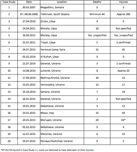
Table 1 – Case studies for 122 mm rockets
BRIEF DESCRIPTIONS
Case Study No 1
On 30 March 2007, the Al Hayat Hospital in Mogadishu, Somalia was hit by a single 122 mm rocket. The Ethiopian forces were advancing northwards in the city, engaging Al Shabab fighters as they went. Three people were injured in the attack. A number of rooms in the hospital were damaged, as were several cars.
Case Study No 2
During the night of 7 August 2008 and the day of 8 August 2008, there was an attempt to capture the town of Tskhinvali from South Ossetian separatists. The ensuing bombardment lasted approximately 18 hours, and involved 27 BM-21 type launchers and other artillery. At least 44 people were killed, and 280 injured by the bombardment. Extensive damage was caused to homes and infrastructure.
Case Study No 3
On 27 April 2010, more than twenty 122 mm rockets were fired into Zintan, Libya. Two of these rockets landed inside the Zintan Public Hospital complex, and another landed just outside the main gate. Four people were killed, and nine injured in the attack. Damage included the hospital parking area, the main gate, and the entrance to emergency services, as well as four nearby houses.
Case Study No 4
At 07:00 on the morning of 14 April 2011, a single 122 mm rocket hit a line of people queuing for bread in Misrata, Libya. Ten people were killed, and an unknown number were injured. At least five more 122 mm rockets and other explosive ordnance hit the same area that morning, with four people dead. It is not possible to determine conclusively that the 122 mm rockets caused their deaths.
Case Study No 5
On 16 April 2011, Misrata was subjected to an artillery barrage which lasted at least two hours. Many 122 mm rockets fell in and around the Al Naseem Dairy, which was one of the largest privately owned companies in Libya. Casualty reports range from none to six, but the rockets did cause in excess of $20 million of damage to the dairy complex.
Case Study No 6
On 31 July 2011, a single 122 mm rocket hit a house in the Al Sawani District of Tripoli, Libya. Five people were killed, and at least two more were injured.
Case Study No 7
On 24 July 2013, two 122 mm rockets hit a residential area close to the Hamdan Bakery in Yarmouk Camp, Damascus, Syria. Fifteen people were killed, and forty-five people injured. Many residential buildings and commercial properties were extensively damaged or destroyed. Multiple vehicles were destroyed. Roads were damaged by craters and made impassable by falling debris. Water mains were also damaged.
Case Study No 8
On 1 February 2014, BM-21 type systems were used for six hours to bombard the Sarir Power Station in Al Kufrah, Libya. Workers had been evacuated from the compound some days earlier, so no casualties were reported. However, workers’ accommodation blocks and two of the power station’s six turbines were damaged.
Case Study No 9
At 10:30 on the morning of 21 July 2014, at least three 122 mm rockets fell in a residential area south of Donetsk railway station, Ukraine. Three people were confirmed killed, and another two were confirmed injured. It is highly probable that more casualties were caused. Multiple apartment buildings and a school were damaged.
Case Study No 10
At approximately 14:00 on 13 August 2014, at least five rockets (believed to be 122 mm rockets) struck Luhansk, Ukraine. Eight people were killed and twenty injured in the attack, which also damaged apartment buildings, shops and vehicles.
Case Study No 11
Between 08:45 and 11:40 on the morning of 17 September 2014, multiple rockets were fired at Nyzhnya Krynka, Ukraine. Ten people were killed, and twelve injured. Nine houses were also destroyed.
Case Study No 12
At 14:35 on 13 January 2015, at least 25 122 mm rockets were launched against the Buhas military checkpoint, 2 km north of Volnovakha on the H20 road, Ukraine. The checkpoint was undamaged but 12 civilians were killed, and 17 injured, when one of the rockets impacted 10 m from a bus.
Case Study No 13
At 14:23 on 14 October 2014, four 122 mm rockets hit the town of Sartana, Ukraine. One of the rockets hit a funeral procession on the main street, killing seven people and injuring another fourteen.
Case Study No 14
At 23:00 on 16 January 2015, between seven and ten 122 mm rockets fell on the Kirov district in Donetsk, Ukraine. Two people were confirmed killed in the attack. There are no reports of any injured people. Multiple houses were damaged.
Case Study No 15
At 07:40 on the morning of 19 January 2015, approximately thirty 122 mm rockets were fired at the town of Debaltseve, Donetsk Oblast, Ukraine. Three people were killed, and another twelve injured. Multiple houses were destroyed and damaged, and at least one shop/restaurant was destroyed. Infrastructure damage included a school, a kindergarten, and roads.
Case Study No 16
On 23 January 2015, 20 122 mm rockets impacted the city of Mosul which was then under the control of the Islamic State group. The rockets were fired from 20 km away, at maximum range. Artillery was also used during this attack, and it is not possible to segregate the damage caused by the different weapon systems. The attack killed 13 people, and injured 44. Some of those killed were victims of a cloud of chlorine gas that was released when a water sterilisation plant was hit.
Case Study No 17
At 09:15 on 24 January 2015, between 19 and 26 rockets hit a district of Mariupol, Ukraine. The rockets came from both Grad and Uragan weapon systems. At least 29 people were reported killed, and at least 93 injured. In addition to the human casualties caused, the attack also damaged four schools, three kindergartens, fifty-three apartment buildings, at least fourteen private houses, as well as several stores and multiple cars.
Case Study No 18
At 14:00 on 1 February 2015, a single 122 mm rocket hit the headquarters of the Joint Centre for Control and Coordination (JCCC), which is a joint Ukrainian and Russian body established to monitor the implementation of the ceasefire in Ukraine. Four people were injured.
Case Study No 19
At 22:00 on 12 July 2015, at least twelve 122 mm rockets were fired at Maryinka, Donetsk Oblast, Ukraine. The rockets were launched from a range of approximately 9 km, and caused the deaths of six people, while injuring another fifteen. Extensive damage was caused to homes in the town. There are unconfirmed reports that the attack also hit an orphanage, a cattle feed plant, a milk factory, a former tyre plant, and water purification station. The town was left without water.
Case Study No 20
At 16:00 on 19 July 2015, five 122 mm rockets impacted the town of Pervaya Ploshchad in Ukraine. Five people were injured in the attack, which also damaged a residential apartment complex, school, and a church. A house was also destroyed.
ANNEX B: CASE STUDIES
CASE STUDY 1
Date/time of attack:
30 March 2007, time not specified.
Location:
Al Hayat Hospital, Mogadishu, Somalia.
Map of the area:
Map of the general area unavailable; see Figure 2 for a map of attacks in Mogadishu.
Weapon System:
BM-21 type MBRL.
Number of rockets fired:
One.
Range rocket fired from:
Unknown.
Impact area:
Not applicable.
Casualties:
Three people wounded (including one doctor) – no further details of the severity of wounds.
Damage:
Several cars, and a number of rooms in a hospital.
Infrastructure damage:
Hospital building.
Distance from detonation:
Unknown, although the rocket struck the hospital building.
Remarks:
Witnesses believe that this was a Grad attack but could not confirm. Human Rights Watch (HRW) comments that residents of Mogadishu were adept at identifying Grad rockets by the whistling sound they made.
Source(s):
- Human Rights Watch: https://www.hrw.org/report/2007/08/13/shell-shocked/civilians-under-siege-mogadishu#_ftn120
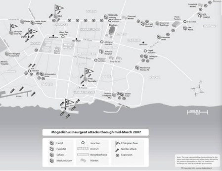
Figure 2. Map of insurgent attacks in Mogadishu through mid-March 2007 (source: Human Rights Watch).
CASE STUDY 2
Date/time of attack:
The night of 7 August 2008, through to the day of 8 August 2008. Approximately 18 hours.
Location:
Tskhinvali, South Ossetia/Georgia.
Map of the area:
See Figure 3
Weapon system:
BM-21 type MBRL, tank guns, field artillery, air-launched munitions.
Number of rockets fired:
A large number, fired over 18 hours.
Range rocket fired from:
Unknown.
Estimated impact area:
Area of bombardment covering 3-4 square kilometres.
Casualties:
Minimum of 44 deaths, approximately 280 wounded (by all weapon systems involved in the bombardment).
Damage:
The hospital was hit, causing extensive damage to treatment rooms on the second and third floors. Several houses on Abaev Street were completely destroyed, or severely damaged. On the southern section of Stalin Street, several apartment buildings sustained multiple hits. At 04:20 on 8 August, three 122 mm rockets hit Number 96 Stalin Street almost simultaneously. One of these injured two women.
Infrastructure damage: Hospital building.
Distance from detonation:
N/A.
Remarks:
The overnight bombardment of 7-8 August 2008 included other weapon systems. South Ossetian forces occupied many civilian buildings during the bombardment.
Source(s):
- Human Rights Watch: https://www.hrw.org/report/2009/01/23/flames/humanitarian-law-violations-and-civilian-victims-conflict-over-south
- The Washington Post: http://www.washingtonpost.com/wp-dyn/content/article/2008/08/16/AR2008081600502_4.html?sid=ST2008081700211
- BBC: http://news.bbc.co.uk/2/hi/in_depth/7692751.stm
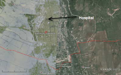
Figure 3. Map showing the location of the hospital in Tskhinvali, South Ossetia/Georgia 2007 (image credit: Google Earth).
CASE STUDY 3
Date/time of attack:
27 April 2011, time not specified.
Location:
Zintan Public Hospital/Medical Center, Al Zintan, Libya.
Map of the area:
See Figure 4
Weapon system:
BM-21 type MBRL.
Number of rockets fired:
20+
Range rocket fired from:
Unknown.
Estimated impact area:
73,512m2 – see Figure 4
Casualties:
Four civilians dead, nine wounded – no information on wounds.
Damage:
The parking area, main gate, and the entrance to emergency services, as well as four nearby houses.
Infrastructure damage:
The main damage to the hospital was the car park, the main gate and the entrance. The car park had two craters caused by 122 mm rockets, and there was another crater on the street by the front gate from the same attack.
Distance from detonation:
Not known – however, it is assumed that at least one of the rockets landed in front of the hospital, just north of its main parking lot. See Figure 4
Remarks:
Included a 4 year-old girl hit in the head with BM-21 fragments.
Source(s):
- SBS: http://www.sbs.com.au/news/article/2011/04/28/Grad-rockets-shower-libyan-town
- Human Rights Watch: https://www.hrw.org/news/2011/05/27/libya-rocket-attacks-western-mountain-towns
- Amnesty International: https://www.amnesty.org/…/mde190202011en.pdf
- Libya Archive Site (primary source: Al Jazeera): http://archive.libyafeb17.com/2011/04/april-28th-pupdates/
Video:
- Youtube: https://www.youtube.com/watch?v=a5Z76CnJpF4
The video is dated 26 June 2011, thus the damage cannot be confirmed to be from the same attack. However, it indicates the damage caused by 122 mm rockets used in the city of Zintan over the early months of 2011.
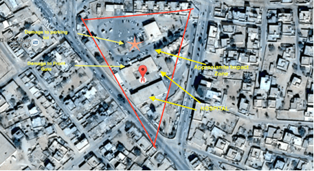
Figure 4 Map showing the Zintan Public Hospital/Medical Center, Al Zintan, Libya (image credit: Google Maps).
CASE STUDY 4
Date/time of attack:
14 April 2011, 07:00-09:00.
Location:
The Balrwein Bakery in the Qasr Ahmed Neighbourhood, Misrata, Libya.
Map of the area:
See Figure 5
Weapon system:
BM-21 type MBRL.
Number of rockets fired:
Six confirmed, possibly more. Other weapon systems were also used.
Range rocket fired from:
Unknown.
Estimated impact area:
Rockets were fired separately to an area of approx. 3 km2 with varying level of impact.
Casualties:
Ten people were killed by a single rocket as they waited in line for bread outside the Balrwein Bakery. The rocket that hit the bread line impacted at 07:00. An additional four people were killed in the same area on the same day, but it is not possible to conclusively attribute their deaths to 122 mm rockets. An unknown number of people were injured.
Damage:
Multiple houses damaged. Vehicles destroyed and damaged.
Infrastructure damage:
A school was damaged.
Distance from detonation:
Unknown.
Remarks:
There were no known military installations or military units in proximity to the impact sites.
Source(s):
- Human Rights Watch: https://www.hrw.org/news/2011/04/17/libya-indiscriminate-attacks-kill-civilians
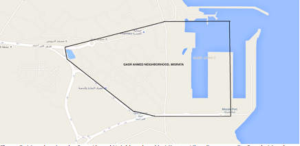
Figure 5. Map showing the Qasr Ahmed Neighbourhood in Misrata, Libya (image credit: Google Maps).
CASE STUDY 5
Date/time of attack:
16 April 2011, early morning.
Location:
The Al Naseem Dairy in Misrata, Libya.
Map of the area:
See Figure 6
Weapon system:
BM-21 type MBRL.
Number of rockets fired:
Not specified, but over 100 claimed.
Range rocket fired from:
Unknown.
Estimated impact area:
Not specified.
Casualties:
There are conflicting reports of casualties, ranging from 0 to 6.
Damage:
According to the chairman of the Al-Naseem Dairy, 122 mm rockets caused damage in excess of $20 million and forced the company to close.
Infrastructure damage:
Not specified.
Distance from detonation:
Various.
Remarks:
The Al-Naseem Dairy was one of the largest private companies in Libya, employing around 750 staff.
Source(s):
- Al Jazeera: http://www.aljazeera.com/news/africa/2011/04/20114168572393746.html
- BBC: www.bbc.co.uk/news/business-16657567
- BBC: http://www.bbc.com/news/business-16366285
- Reuters: http://www.reuters.com/article/2011/04/17/us-libya-misrata-idUSTRE73G1A920110417
- Al-Naseem: http://www.alnaseemdairy.com/
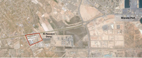
Figure 6. Map showing the general area surrounding the Al Naseem Dairy in Misrata, Libya (image credit: Google Earth).
CASE STUDY 6
Date/time of attack:
31 July 2011, time not specified.
Location:
Al Sawani district, Tripoli, Libya.
Map of the area:
See Figure 7
Weapon system:
BM-21 type MBRL.
Number of rockets fired:
One.
Range rocket fired from:
Unknown.
Estimated impact area:
Not applicable.
Casualties:
Five dead, including a woman eight months pregnant who received fragment wounds to the stomach causing her to miscarry. A 10 year-old girl was among the dead, after being hit in the head by fragmentation. At least two people were injured in the same incident: a 14 year-old boy, and a woman in her sixties. All of those killed and injured came from the same family.
Damage:
Not specified.
Infrastructure damage:
Not specified.
Distance from detonation:
Unknown.
Remarks:
The Al-Sawani district is situated near to Tripoli Airport.
Source(s):
- Amnesty International: https://www.amnesty.org/en/latest/news/2014/08/libya-indiscriminate-shelling-civilian-areas-tripoli-and-benghazi-amounts-war-crimes/
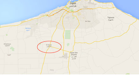
Figure 7. Map showing Al Sawani district, Tripoli, Libya (image credit: Google Maps).
CASE STUDY 7
Date/time of attack:
24 July 2013, during the day time.
Location:
Residential buildings near the Hamdan Bakery, Yarmouk Camp (8 km from Damascus City Centre, Syria).
Map of the area:
See Figure 8
Weapon system:
BM-21 type MBRL.
Number of rockets fired:
Two.
Range rocket fired from:
Unknown.
Estimated impact area:
Unknown.
Casualties:
Fifteen dead (five women, five children, and five members of a family), 45 people wounded – no details of severity of wounds.
Damage:
A residential and shopping area were hit; one building was destroyed, and collapsed two days later. Many residential buildings and commercial properties were extensively damaged. Multiple vehicles were destroyed.
Infrastructure damage:
Roads were damaged by craters and debris from collapsed buildings. Water mains were damaged.
Distance from detonation:
Unknown.
Remarks:
Getting access to reports of attacks anywhere in Syria is very difficult, and so is establishing its veracity through multiple sources. However, organisations that provided the numbers and the visuals are used by independent news agencies and organisations, such as Human Rights Watch. Though there are limitations to credibility, these few agencies are the only source of information to anyone outside the country.
Sources:
- The Monthly Report on the Martyrs of Dignity’s Revolution: Violation Documentation Center in Syria, July 2013
- Reuters: http://www.reuters.com/article/2013/07/24/us-syria-crisis-palestinians-idUSBRE96N1DH20130724
- International Support Kurds in Syria Association (SKS): http://supportkurds.org/news/wednesday-24-july-2013/
Videos:
- Syrian Network for Human Rights: http://www.vdcsy.info/index.php/en/reports/july2013#.VbeVQfmqqko
- YouTube: https://www.youtube.com/watch?v=pPbs-miIoNI
- YouTube: https://youtu.be/ApUnMYWAAi8 (victims)
- YouTube: https://youtu.be/N44Vd5whLEk (victims)
- YouTube: https://www.youtube.com/watch?v=VByGDBh9kjk (damage to infrastructure)
- YouTube: https://www.youtube.com/watch?v=wcLvCyzwAng (damage to infrastructure)
- YouTube: https://www.youtube.com/watch?v=u_BpEnHDiuE (damage to infrastructure)
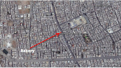
Figure 8. Map showing the area surrounding the Hamdan Bakery, Yarmouk Camp (image credit: Google Earth).
Photos of the damage:
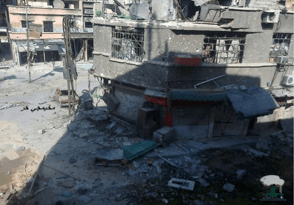
Photo 7. Damaged residential buildings in the Yarmouk Camp, Syria (photo credit: Center for Documentation of Violations in Syria).
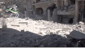
Photo 8. Destroyed buildings near the Hamdan Bakery, in the Yarmouk Camp, Syria (photo credit: Syrian Network for Human Rights).
CASE STUDY 8
Date/time of attack:
1 February 2014, 10:00-16:00.
Location:
Sarir Power Station, Al Kufrah, Libya.
Map of the area:
See Figure 9
Weapon system:
BM-21 type MBRL.
Number of rockets fired:
During the six hour bombardment, a considerable number of rockets were fired.
Range rocket fired from:
Approximately 15 km.
Estimated impact area:
Unknown, but the impact area included the Al-Shola oil compound.
Casualties:
No casualties were reported.
Damage:
Workers’ accommodation buildings were destroyed.
Infrastructure damage:
Two of the power station’s six turbines had been damaged.
Distance from detonation:
Various.
Remarks:
This power station is a key source of electricity for Tripoli and Benghazi. At the time of the attack, the power station was not operational, owing to security concerns.
Source(s):
- Fred Cathasisours: http://fredw-catharsisours.blogspot.com/2014/02/libya-updates-february-2-2014-latest.html
- Reuters: http://www.reuters.com/article/2014/02/25/us-libya-power-idUSBREA1O1AU20140225
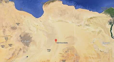
Figure 9. General map of the area surrounding Sarir Power Station, Al Kufrah, Libya (source: Google Maps).
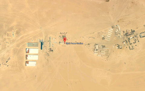
Figure 10. Detailed map of the area surrounding Sarir Power Station, Al Kufrah, Libya (source: Google Maps).
CASE STUDY 9
Date/time of attack:
21 July 2014, 10:30.
Location:
Residential area south of Donetsk Railway Station, Donetsk, Ukraine.
Map of the area:
See Figure 11
Weapon system:
BM-21 type MBRL.
Number of rockets fired:
Three impact sites recorded, but more unconfirmed.
Range rocket fired from:
Unknown.
Estimated impact area:
Triangular area, approximately 200 m x 100 m.
Casualties:
Three confirmed dead, and two confirmed injured, but it is highly probable that more casualties were caused.
Damage:
Apartment buildings damaged.
Infrastructure damage:
School damaged.
Distance from detonation:
Various.
Remarks:
Attacks continued after this incident, which made further investigation difficult.
Source(s):
- Human Rights Watch: https://www.hrw.org/news/2014/07/24/ukraine-unguided-rockets-killing-civilians
- The Washington Post: https://www.washingtonpost.com/world/2014/07/21/86cd2a12-10b0-11e4-98ee-daea85133bc9_story.html
- The Guardian: http://www.theguardian.com/world/2014/jul/21/ukrainian-forces-assault-separatist-donetsk-mh17-torez
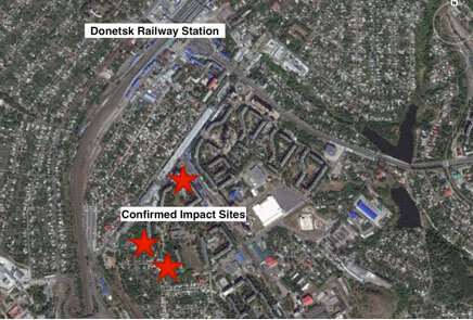
Figure 11. Map of the area south of Donetsk Railway Station, and confirmed impact sites (source: Google Earth).
CASE STUDY 10
Date/time of attack:
13 August 2014, at approximately 13:00.
Location:
The intersection of Budenov and Karpinsky streets, Vatunina district, Luhansk, Ukraine.
Map of the area:
See Figure 12
Weapon system:
BM-21 type MBRL and artillery. There was continuous heavy shelling by various weapon systems, including the BM-21 type MBRL, in the area in July-August 2014. The BM-21 type MBRL was the preferred weapon at the time, suggesting a 122 mm rocket attack.
Number of rockets fired:
At least five.
Range rocket fired from:
Unknown.
Estimated impact area:
Unknown.
Casualties:
Eight killed, including children. Multiple sources reported at least 20 casualties as a result of shelling of eastern Luhansk.
Damage:
A number of apartment buildings, with one shop destroyed and other shops damaged, various vehicles, and a bus. See Figures 12 and 13 for more precise information.
Infrastructure damage:
A gas leak was reported in one building.
Distance from detonation:
Unknown.
Remarks:
Luhansk was under siege from July-August 2014, and was continuously shelled during that time.
Source(s):
- Ukrainian People’s News (UNN): http://www.unn.com.ua/ru/news/1375784-u-lugansku-pid-obstril-potrapilo-perekhrestya-bilya-skhidnoukrayinskogo-universitetu-sotsmerezhi (single source, in Ukrainian)
- Human Rights Watch: https://www.hrw.org/news/2014/08/15/dispatches-fleeing-luhansk (in English)
- Human Rights Watch: https://www.hrw.org/news/2014/09/01/ukraine-rising-civilian-toll-luhansk
- Ukrainian Pravda: http://www.pravda.com.ua/rus/news/2014/08/14/7034791/ (in Russian)
- RBK Ukraine: http://www.rbc.ua/rus/news/v-luganske-13-avgusta-v-rezultate-artobstrelov-pogibli-14082014110700
- Ukrainian Pravda: http://www.pravda.com.ua/news/2014/08/13/7034730/ (single source, in Ukrainian)
Videos:
- Youtube: https://www.youtube.com/watch?v=I-b9gGyQ41o (in Ukrainian and Russian)
- Youtube: https://www.youtube.com/watch?v=82tOG4zdEkk (single source, very graphic content, in Russian)
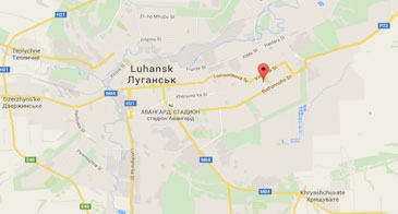
Figure 12. Map of the area of the Vatunina district, Luhansk, Ukraine (source: Google Maps).

Figure 13. Detailed structural damage in the area of the Vatunina district, Luhansk, Ukraine (source: Google Maps).
CASE STUDY 11
Date/time of attack:
17 September 2014, from 08:45-11:40 .
Location:
Nyzhnya Krynka, Donetsk Oblast, Ukraine.
Map of the area:
See Figure 14
Weapon system:
BM-21 type MBRL.
Number of rockets fired:
Multiple rockets fired during a 2 hour 55 minute period.
Range rocket fired from:
Unknown.
Estimated impact area:
Not applicable.
Casualties:
Ten dead, twelve people wounded – no details of severity.
Damage:
Nine houses destroyed.
Infrastructure damage:
Unknown.
Distance from detonation:
Various.
Remarks:
There were military targets in the area; it is not known how many military casualties there were.
Source(s):
- CNN: http://www.cnn.com/2014/09/17/world/europe/ukraine-crisis/
- Liveleak: http://www.liveleak.com/view?i=9af_1410984042
- UPI: http://www.upi.com/Top_News/World-News/2014/09/18/Rebel-rocket-attack-kills-10-in-Ukraine/9921411058781/
- Lifeinua: http://lifeinua.info/terrorists-shelled-village-donetsk-oblast-Grad-multiple-rocket-launcher-system-10-people-died/
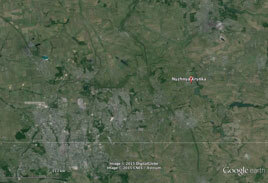
Figure 14. Map of Nyzhnya Krynka, Donetsk Oblast, Ukraine (source: Google Earth).
CASE STUDY 12
Date/time of attack:
13 January 2015, 14:35.
Location:
Buhas checkpoint, 2 km north of Volnovakha on the H20 road, Ukraine (35 km south-west of Donetsk).
Map of the area:
See Figure 15
Weapon system:
BM-21 type MBRL.
Number of rockets fired:
Approximately 25.
Range rocket fired from:
Suggested 15-17 km, but unconfirmed.
Estimated impact area:
Video footage shows an area in excess of 100 m x 100 m but exact size estimate is not possible.
Casualties:
12 killed, 17 injured – no further details of severity of wounds. Ten passengers died instantly, and the other two dead died later in hospital.
Damage:
One bus severely damaged.
Infrastructure damage:
None reported.
Distance from detonation:
10 m.
Remarks:
OSCE crater examination confirmed use of 122 mm rockets. It is likely that the checkpoint was the target of the attack, but the checkpoint sustained no damage.
Source(s):
- OSCE: http://www.osce.org/ukraine-smm/135211
- OSCE: http://www.osce.org/ukraine-smm/134636
- Interfax Ukraine: http://en.interfax.com.ua/news/general/244242.html
- US Department of State: http://www.state.gov/r/pa/prs/dpb/2015/01/235916.htm#UKRAINE
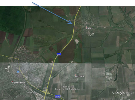
Figure 15. Map of the area around the Buhas checkpoint, 2 km north of Volnovakha on the H20 road, Ukraine
(source: Google Earth).
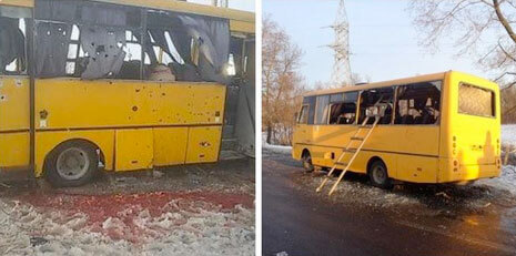
Photo 11. Photo of the damaged bus (source: DNR).
CASE STUDY 13
Date/time of attack:
14 October 2014,14:23.
Location:
Sartana, Donetsk Oblast, Ukraine (19 km northeast of Mariupol).
Map of the area:
See Figure 16
Weapon system:
BM-21 type MBRL.
Number of rockets fired:
Four, although it appears that all casualties were caused by a single rocket.
Range rocket fired from:
Unknown.
Estimated impact area:
Unknown.
Casualties:
Seven dead, fourteen injured (seven males and seven females, aged between 33 and 65). Two of the injured were described as being in a serious condition. A doctor said that all people admitted had fragmentation (shrapnel) injuries.
Damage:
Unknown.
Infrastructure damage:
Road damaged, no further information.
Distance from detonation:
Unknown.
Remarks:
All of the victims were in a funeral procession on the main street (General Kurkchi Street) when the rockets struck. The rocket that caused the deaths and injuries hit the road at the intersection of General Kurkchi Street and Krainyaya Street. There is a Ukrainian government military position approximately 500 m north-west of the impact site, and numerous other military positions in the area.
Source(s):
- OSCE: http://www.osce.org/ukraine-smm/125545
- Military Maps: http://militarymaps.info/?lat=47.1781125&lng=37.6807665&z=13&t=5
- Reuters: http://acloserlookonsyria.shoutwiki.com/wiki/Grad_shelling_of_Sartana
- Ridus News: http://www.ridus.ru/news/169622?page=2#63
Videos:
- Youtube: https://www.youtube.com/watch?v=N9HzElNxh10
- Youtube: https://www.youtube.com/watch?v=8e-SfdOe0zA
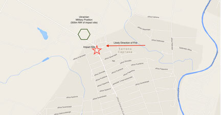
Figure 16. Map of Sartana, Donetsk Oblast, Ukraine (source: Google Maps).
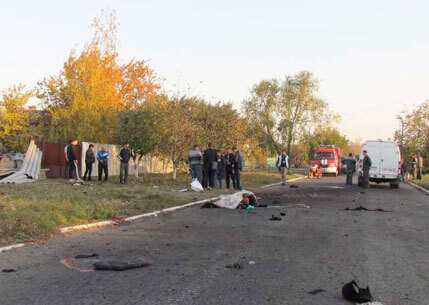
Photo 12. The aftermath of the Sartana attack (photo credit: Nikolay Ryabchenko/Reuters).
CASE STUDY 14
Date/time of attack:
16 January 2015, 23:00.
Location:
Kirov district, Donetsk, Ukraine.
Map of the area:
See Figure 17
Weapon system:
BM-21 type MBRL.
Number of rockets fired:
Seven confirmed, three more probable.
Range rocket fired from:
10-12 km.
Estimated impact area:
Not specified.
Casualties:
Two women killed.
Damage:
Multiple houses.
Infrastructure damage:
Not specified.
Distance from detonation:
One woman was killed when a rocket hit the bathroom she was in, thus the distance was less than 5 metres.
Remarks:
The rockets are claimed to have killed people at 28 Komsomolu Ukrainy Street, and 5 Gogol Street. Neither of these locations, or any with similar names, could be located in the area.
Source(s):
- Human Rights Watch: https://www.hrw.org/news/2015/02/03/ukraine-rising-civilian-death-toll

Figure 17. Map of the Kirov district, Donetsk, Ukraine (source: Google Maps).
CASE STUDY 15
Date/time of attack: 19 January 2015, 07:40.
Location:
Debaltseve, Donetsk Oblast, Ukraine.
Map of the area:
See Figure 18
Weapon system:
BM-21 type MBRL.
Number of rockets fired:
Approximately 30.
Range rocket fired from:
Approximately 19 km.
Estimated impact area:
Stated as being approximately 1 km2.
Casualties:
Three dead, twelve people injured – no further details of severity of wounds.
Damage:
Multiple houses destroyed and damaged. At least one shop/restaurant destroyed.
Infrastructure damage:
Roads damaged, one school damaged, and one kindergarten damaged.
Distance from detonation:
Various.
Source(s):
- OSCE: http://www.osce.org/pc/137151?download=true
- OSCE: http://www.osce.org/ukraine-smm/135821
- UNIAN: http://www.unian.info/society/1035039-osce-concludes-debaltseve-Grad-attack-came-from-militant-held-area-video.html
- UARP: http://uarp.org/en/news/1421851501
- IB Times: http://www.ibtimes.co.uk/powerful-photos-by-heidi-levine-winner-anja-niedringhaus-courage-photojournalism-award-1493358
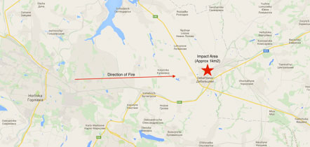
Figure 18. Map of Debaltseve, Donetsk Oblast, Ukraine (source: Google Maps).
CASE STUDY 16
Date/time of attack:
23 January 2015, time not specified.
Location:
Mosul, Iraq.
Map of the area:
See Figure 19
Weapon system:
Iranian copy of BM-21 type MBRL (HM-20).
Number of rockets fired:
20.
Range rocket fired from:
Approximately 20 km.
Estimated impact area:
Undefined.
Casualties:
Thirteen dead, forty-four people injured. Six were killed when a rocket struck a shop. Others were killed and injured when another rocket struck a water sterilisation plant, releasing a cloud of toxic chlorine gas. There are claims that ISIL targets were also hit, but this is unconfirmed.
Damage:
Not specified.
Infrastructure damage:
Water sterilisation plant.
Distance from detonation:
Unknown.
Remarks:
Both rockets and artillery were used in this attack. It is not possible to distinguish between those casualties caused by 122 mm rockets and artillery.
Source(s):
- The New Arab: http://www.alaraby.co.uk/english/politics/2015/1/26/is-held-mosul-pounded-by-kurdish-rockets
- World Tribune: http://www.worldtribune.com/2015/01/25/kurds-advance-launch-rocket-attacks-isil-mosul/
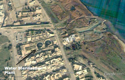
Figure 19. Map showing the water sterilisation plant in Mosul, Iraq (source: Google Earth).
CASE STUDY 17
Date/time of attack:
24 January 2015, approximately 09:15.
Location:
Vostochniy (“Eastern”) micro-district of Mariupol, Ukraine (NB: OSCE Special Monitoring Mission (SMM) reported Ordzhonikidzevskyi district being hit). 8.5 km north-east of Mariupol city centre, and approximately 400 m from a Ukrainian Armed Forces checkpoint. Most rockets fell along and around Olympiskaya and Kievskaya streets.
Map of the area:
See Figure 20
Weapon system:
BM-21 type MBRL and BM-27 Uragan. There is no available information on the Uragan hits individually, but the use of the Uragan was explicitly reported by SMM in Mariupol.
Number of rockets fired:
SMM reported at least 19; HRW reported more than 20; unconfirmed YouTube recordings of the aftermath mention 25-26 rockets fired. There is no breakdown of the numbers of Grad and Uragan rockets fired.
Range rocket fired from:
SMM’s impact analysis showed that 122 mm rockets were fired from a north-easterly direction, in the area of Oktyabr (19 km north-east of Olimpiiska Street), and the Uragan rockets from an easterly direction, in the area of Zaichenko (15 km east of Olimpiiska Street).
Estimated impact area:
At least 1.6 km x 1.1 km, according to SMM.
Casualties:
At least 29 dead, including two children, and at least 93 wounded and hospitalised, including approximately 40 in critical state.
Damage:
53 multi-storey apartment buildings, at least 14 direct hits of private houses, as well as several stores, and multiple cars.
Infrastructure damage:
Four schools, three kindergartens were damaged.
Distance from detonation:
Unknown. Some rockets were direct hits into buildings (e.g., in the private sector, or in the Kievsky market).
Remarks:
It is not possible to distinguish between the damage caused by Grad and by Uragan rockets, as news sources, HRW and SMM, generally report damage and casualties from the attack as a whole. Mariupol City Council reported that three Grad systems were fully discharged during the attack; this information, however, could not be cross-checked through other sources. Additionally, later the same day (at 13:02 and 13:21) there were two more attacks, which hit the Ukrainian army checkpoint. This suggests that the checkpoint was also the initial target of the morning attack.
Source(s):
- Organization for Security and Co-operation in Europe: http://www.osce.org/ukraine-smm/136061
- Human Rights Watch: http://www.hrw.org/news/2015/01/24/dispatches-rebels-likely-behind-deadly-rocket-attacks-mariupol
- TSN: http://tsn.ua/ukrayina/blizko-40-postrazhdalih-pid-chas-krivavogo-obstrilu-mariupolya-u-nadvazhkomu-stani-404943.html (in Ukrainian)
- Ukrainian Pravda: http://www.pravda.com.ua/rus/news/2015/01/24/7056228/ (in Russian)
- Mariupol City Council: http://marsovet.org.ua/news/show/id/8135(in Russian)
- Twitter: https://twitter.com/olesolvang/status/559247607655325696
Videos:
- Youtube: https://youtu.be/_r9kvgFzWwI (in Russian)
- Youtube: https://youtu.be/IzmuS_gYwtM (in Russian)
- Youtube: https://www.youtube.com/watch?v=78QgiyjtyBg (in Russian)
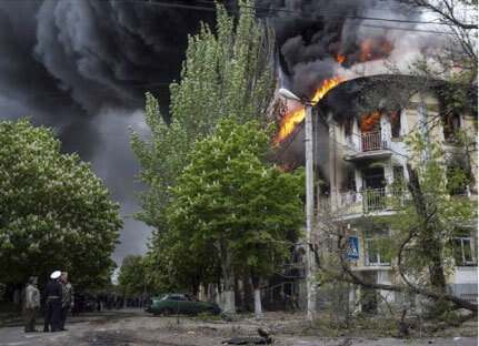
Photo 13. An apartment building on fire in Mariupol, Ukraine (source: AP).
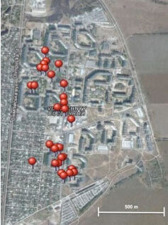
Figure 20. Map showing the hit locations in the Vostochniy (“Eastern”) micro-district of Mariupol, Ukraine (source: Twitter user @loydstern).
CASE STUDY 18
Date/time of attack:
1 February 2015, 14:00.
Location:
JCCC Headquarters, Debaltseve, Ukraine.
Map of the area:
Not available.
Weapon system:
BM-21 type MBRL.
Number of rockets fired:
One.
Range rocket fired from:
Unknown.
Estimated impact area:
N/A.
Casualties:
Four people injured, three civilians, and the Ukrainian Armed Forces Chief of Staff attached to the JCCC HQ.
Damage:
JCCC HQ building damaged.
Infrastructure damage:
Not specified.
Distance from detonation:
Various.
Remarks:
Joint Centre for Control and Coordination (JCCC) is a joint Ukrainian and Russian body established to monitor the implementation of the ceasefire in Ukraine. Rockets hit both the HQ building, and the area around it.
Source(s):
- Organization for Security and Co-operation in Europe: http://www.osce.org/ukraine-smm/138616
- TASS: http://tass.ru/en/world/752774
CASE STUDY 19
Date/time of attack:
12 July 2015, 22:00.
Location:
Maryinka, Donetsk Oblast, Ukraine.
Map of the area:
See Figure 21
Weapon system:
BM-21 type MBRL.
Number of rockets fired:
Minimum of 12.
Range rocket fired from:
Approximately 9 km.
Estimated impact area:
After measuring the area of the apartment buildings, the minimum possible area is 240 m x 60 m, but the actual area is likely to be larger.
Casualties:
Six dead (aged between 45-60), fifteen people wounded.
Damage:
Twelve apartment buildings suffered direct hits. Most buildings in the area lost their windows.
Infrastructure damage:
Unconfirmed reports that the attack hit an orphanage, a cattle feed plant, a milk factory, a former tyre plant, and water purification station. It was confirmed that the town was left without water.
Distance from detonation:
Various.
Remarks:
HRW found parts of 122 mm rockets after the attack. Damage reports came from a local militia and are found to be unreliable due to lack of cross-checking of the evidence of damage.
Source(s):
- Human Rights Watch: https://www.hrw.org/news/2014/07/24/ukraine-unguided-rockets-killing-civilians
- English Russia: http://englishrussia.com/2014/08/26/when-a-multiple-launch-rocket-system-Grad-hits-the-target/
- RT: http://www.rt.com/news/172288-civilians-killed-ukraine-orphanage/
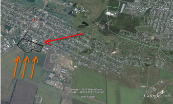
Figure 21. Map showing the impact locations of the rockets in Maryinka, Donetsk Oblast, Ukraine (source: Google Earth).
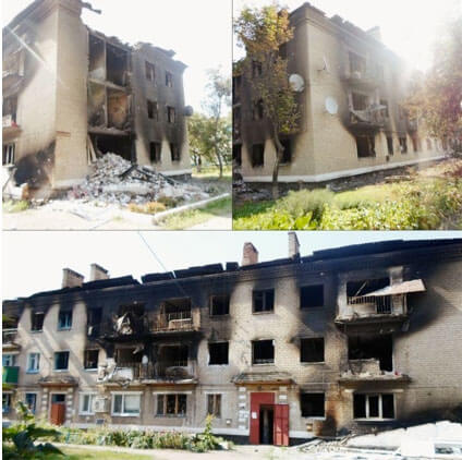
Photo 14. Apartment buildings that were destroyed in an attack on Maryinka, Donetsk Oblast, Ukraine (source: Magacin.org)
CASE STUDY 20
Date/time of attack:
19 July 2015, at approximately 16:00.
Location:
Pervaya Ploshchad, Kuibyshivskyi district, Donetsk, Ukraine.
Map of the area:
See Figure 22
Weapon system:
BM-21 type MBRL.
Number of rockets fired:
Five – one rocket hit six Tumanyana Street, wounding one person. A second rocket hit a courtyard 20 m away from the first, injuring four people – one seriously, with a fragmentation wound to the chest. A third rocket struck the playground of School 71; a fourth hit the road outside the local church, shattering most of the windows; and a fifth hit a single-storey house that was empty at the time.
Range rocket fired from:
Several kilometres.
Estimated impact area:
Unknown.
Casualties:
Five people wounded – no further details of severity of wounds.
Damage:
Residential apartment complex, school, church, and house destroyed.
Infrastructure damage:
Road outside local church and school.
Distance from detonation:
Various.
Remarks:
HRW found fragments of 122 mm rockets at the scene.
Source(s):
- Human Rights Watch: https://www.hrw.org/news/2014/07/24/ukraine-unguided-rockets-killing-civilians
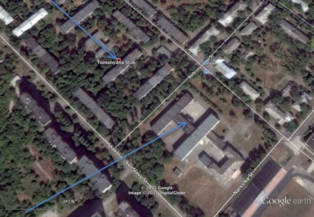
Figure 22. Map of the Pervaya Ploshchad, Kuibyshivskyi district, Donetsk, Ukraine (source: Google Earth).
The views expressed in this publication are those of the authors and do not necessarily represent the views of the GICHD. The designation employed and the presentation of the material in this publication do not imply the expression of any opinion whatsoever on the part of the GICHD concerning the legal status of any country, territory or armed groups, or concerning the delimitation of its frontiers or boundaries.